- Community
-
- About Sherwood Sherwood Heritage Center Chamber of Commerce Marjorie Stewart Center Sherwood Center for the Arts Sherwood YMCA Family Resources
- Events and Activities City Calendar Library Events Community Events Event Permits Monument Posting Request Community Meeting Rooms Recreation Parks and Trails Directory Recreation Programs Sherwood Fieldhouse
- Community Field House Sherwood Demographics Sherwood School District Sherwood Youth Sports Utilities Volunteer Opportunities Highway 99 Pedestrian Crossing Public Safety Police Tualatin Valley Fire & Rescue
-
- Business & Development
- Government
-
- City Council Boards and Committees Urban Renewal Agency Agendas and Minutes Municipal Code Public Records
- Building City Attorney City Manager Code Compliance Community Development Community Services Economic Development Emergency Management Engineering
- Finance Human Resources Library Municipal Court Parks & Recreation Planning Police Public Works Utility Billing
-
- Online Services
-
- Job Opportunities Utility Billing Alerts & Notifications Email Subscriptions Sherwood Flash Alert Police Flash Alert Events and Meetings Agendas and Minutes Calendar
- Contact the City Submit a Request or Concern City Offices Municipal Code Documents and Forms Documents and Reports Forms and Applications
- Social Media
-
Map Catalog
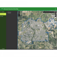
Below is a catalog of maps that can be downloaded and printed out. Each map is maintained on a slightly different schedule based on data changes. If you would like to access data in an interactive environment you can click here Interactive Map.
Disclaimer:
The City of Sherwood's infrastructure records, drawings, and other documents have been gathered over many years, using many different formats and standards. While the data provided is generally believed to be accurate, occasionally it proves to be incorrect; thus its accuracy is not guaranteed. Prior to making any property purchases or other investments based in full or in part upon the material provided, it is specifically advised that you independently field verify the information contained within our records.
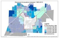
The Sherwood Annexation History Map is provided by the Planning Department. For more information please contact Planning at (503) 925-2308.
This is the Elementary School Boundary within the city limits. If you are unsure which boundary you are in you can also access the information directly from the school districts website
https://www.schoolsitelocator.com/apps/sherwood/

View a map of the areas and dates that the crews will be picking up leaves to keep them out of the storm drains.
This is the Middle School Boundary within the city limits. If you are unsure which boundary you are in you can also access the information directly from the school districts website
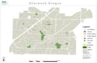
This map is of the City of Sherwood. It contains schools, streets, addresses, taxlots, parks, and trails. Trails have been one thing a number of residents have requested. The trials include city maintained as well as some HOA maintained.
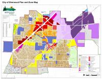
The Sherwood Zoning Map is provided by the Planning Department. For more information please contact Planning at (503) 925-2308. Use the link below for a larger and more detailed view.

When the snow and ice cover the roads, our crews go out to spread sand for improved traction or plow as needed. See when your road might get service.

Our street sweeper rolls through town once a month. View a map to see when we will be on your street.
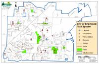
Sherwood has many trails worth exploring. Below is a link to access a map of the trails hidden throughout the City.
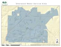
If you want to know if your address is serviced by the City of Sherwood check out the Service Area Map or call the Utility Billing Department at 503 925-2315