
Sherwood West Concept Plan
Sherwood West is a 1,291‑acre regional urban reserve (officially designated as Urban Reserve Area 5B) and represents an opportunity for Sherwood’s long‑term expansion. The area was recently added to the region’s Urban Growth Boundary (UGB) and eventually annexed into the City of Sherwood; it will become a key location for new homes, parks, employment areas, and community amenities.
Positioned directly next to existing neighborhoods, transportation corridors, and utility infrastructure, Sherwood West is the most logical and efficient direction for future growth. Its size and strategic location give the community a thoughtful plan for the next generation.
Status Update
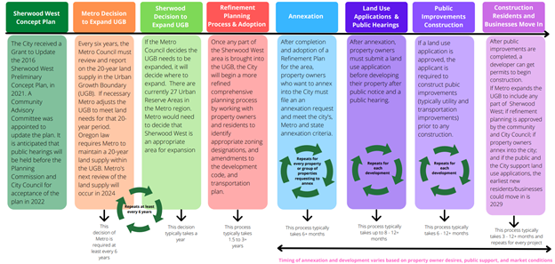
The Sherwood City Council accepted the updated Sherwood West Concept Plan in July 2023. The plan reflects new land‑use needs, transportation patterns, state housing rules, and economic development opportunities. Metro approved expansion of the Urban Growth Boundary (UGB) to include all of Sherwood West in 2024.
An appeal of Metro’s decision was submitted in 2025 to the Department of Land Conservation and Development (DLCD), and Land Conservation and Development Metro Commission (LCDC). A final determination from Metro is expected in 2026.
Comprehensive planning may begin in 2026. Comprehensive planning will focus on internal readiness and long-range organizational strategy. This will include working with residents to identify appropriate zoning designations, and amendments to development code and transportation plan.
• Annexation
• Land Use Applications & Public Hearings
• Public Improvement Construction
• Construction Residents and Businesses Move In
About the Sherwood West Area
Interactive Map: Link To Interactive Sherwood West Map
Sherwood West is located west of the current city limits and adjacent to the Urban Growth Boundary. It is bordered by SW Lebeau Road to the north and SW Chapman Road to the south. As Metro Urban Reserve Area 5b, it is Sherwood’s largest future growth area, made up of 126 properties totaling 1,291 acres.
Project Timeline
• February 2021: Sherwood West Re-Look Planning process began
• 2021–2023: Work guided by a Community Advisory Committee (CAC) and Technical Advisory Committee (TAC)
• July 2023: City Council accepts the Sherwood West Concept Plan
• 2024: Metro approves UGB expansion for all portions of Sherwood West
• 2025: An appeal of Metro’s decision was submitted to DLCD, and again to LCDC
• 2026: Awaiting a final determination from LCDC regarding the appeal
Who was Involved
The Sherwood City Council led the Sherwood West Re‑Look Project, updating the 2016 Sherwood West Preliminary Concept Plan and establishing a new vision for how the 1,291-acre Sherwood West area will grow over time. The plan serves as a long-range guide for the community’s future. The City Council final decision was informed by the Planning Commission recommendations and supported by:
• Community Advisory Committee (CAC)
• Technical Advisory Committee (TAC)
• Local residents, property owners, and stakeholders
• Washington County and regional service providers
• Partner governments and utility agencies
A consultant team led by Angelo Planning Group/MIG supported the effort, including:
• APG/MIG: Project management and land‑use planning
• Leland Consulting Group: Economic development and infrastructure funding
• DKS Associates: Transportation planning
• Walker Macy: Urban design
Community Involvement
Community engagement was central to the Sherwood West planning process. The City conducted a transparent, community driven approach that reflects the needs and priorities of:
• Residents living in or near Sherwood West
• Property owners and those interested in future annexation or development
• Local businesses
• Students and families connected to Sherwood High School
Public input helped shape a concept plan that is representative, sustainable, and aligned with Sherwood’s long‑term goals.
Why the Update Was Needed
Several significant developments occurred since 2016 making it necessary to revisit and refine that vision.
• The Sherwood School District built the new 350,000‑square‑foot Sherwood High School on 73 acres within Sherwood West.
• Washington County completed the Urban Reserve Transportation Study (URTS), offering updated transportation impact data.
• Sherwood adopted its 2040 Comprehensive Plan in 2021.
• Oregon passed House Bill 2001, requiring cities to allow “middle housing” such as duplexes and townhomes in single‑family zones.
• The City Council identified employment land and job creation as a priority, and Sherwood West offers a major opportunity to meet that goal.
The Sherwood City Council accepted the updated Sherwood West Concept Plan in July 2023. The plan reflects new land‑use needs, transportation patterns, state housing rules, and economic development opportunities. Metro approved expansion of the Urban Growth Boundary (UGB) to include all of Sherwood West in 2025.
Infrastructure Funding
The Concept Plan includes a funding strategy for:
• Transportation
• Water
• Sanitary sewer
• Stormwater
• Parks
There is no single funding source for all infrastructure needs. Instead, the plan identifies key projects, estimates costs, evaluates available revenues, and recommends tools and funding mechanisms. Collaboration with developers and partner agencies will help ensure that public facilities are delivered efficiently as development occurs.
 Attachment A – Cover Letter
Attachment B – Title 14 Findings
Attachment D – City Council Resolutions
Attachment E – IGA Washington County
Attachment F1 – Service Provider Letters
Attachment F2 – Housing and Employment Letters of Support
Attachment F3 Attachment – Property Owner and Public Letters of Support
Attachment G – HNA Confirmation
Attachment H – Map of Expansion Area
Attachment C – Concept Plan
Attachment C1 – Concept Plan Appendices
_Table of Contents
Attachment A – Cover Letter
Attachment B – Title 14 Findings
Attachment D – City Council Resolutions
Attachment E – IGA Washington County
Attachment F1 – Service Provider Letters
Attachment F2 – Housing and Employment Letters of Support
Attachment F3 Attachment – Property Owner and Public Letters of Support
Attachment G – HNA Confirmation
Attachment H – Map of Expansion Area
Attachment C – Concept Plan
Attachment C1 – Concept Plan Appendices
_Table of Contents
 Sherwood West Re-Look Presentation
 Welcome to the City of Sherwood’s Notification System, the city’s latest tool for providing residents with immediate information and warnings on water contamination, extreme weather warnings, unexpected road closures, etc. This is a free service provided by the City of Sherwood.